Table of Contents
- 1.The Geography and Layout of Deep Cove
- 2.Housing Typologies and Architectural Eras
- ↳1. Original Recreational Cabins and Cottages
- ↳2. Post-War and 1970s Split-Level Homes
- ↳3. Custom Waterfront and Modern Rebuilds
- 3.Daily Logistics: Transportation, Schools, and Topography
- 4.Site Due Diligence and Physical Risk Assessment
- ↳1. Rainwater Runoff and Perimeter Drainage
- ↳2. Riparian Setbacks and Creek Corridors
- ↳3. Tree Canopy and Wind Exposure
- 5.Market Positioning and Pricing Dynamics
- 6.Assessing Fit: Is Deep Cove the Right Choice?
- 7.Frequently Asked Questions
- ↳How does winter sunlight in Deep Cove compare to other North Vancouver neighbourhoods?
- ↳What should I check when buying a waterfront home on Panorama Drive?
- ↳Are secondary suites permitted in Deep Cove detached homes?
- ↳How severe is summer visitor traffic in the village?
Deep Cove sits at the easternmost point of the North Shore, bounded by the waters of Indian Arm and the steep western flanks of Mount Seymour. For prospective buyers, the neighbourhood represents a deliberate trade-off between natural isolation and urban accessibility, where everyday convenience is balanced against waterfront access and a self-contained village layout.
- Micro-location determines value: Street topography, sun exposure, and proximity to the village commercial node significantly alter pricing and resale velocity within small geographic distances.
- Infrastructure constraints exist: Access relies on two primary arteries (Mount Seymour Parkway and Dollarton Highway), making peak-hour travel times and summer weekend congestion critical lifestyle factors.
- Technical due diligence is mandatory: Steep slopes, high rainfall volume, creek setbacks, and foreshore leases on waterfront parcels require specialized structural and environmental inspections.
- Inventory remains chronically limited: Deep Cove exhibits lower turnover rates than central North Vancouver neighbourhoods, keeping benchmark price levels firm even during slower broader markets.
The Geography and Layout of Deep Cove
Physical geography defines every property line in this community. Unlike the grid systems found in Central Lonsdale or lower North Vancouver, Deep Cove's road network curves around rock outcroppings, ocean coves, and steep forested hillsides. The neighbourhood functions largely as a terminus; there is no through-traffic to other municipalities, which preserves a distinct quietness outside of prime summer recreation periods.
The core of the neighbourhood centres on Gallant Avenue and Panorama Park. Here, a small commercial strip provides basic everyday services, independent cafes, and restaurants. As you move away from the village centre along roads like Panorama Drive, Caledonia Avenue, and Strathcona Road, the environment shifts immediately to residential parcels framed by mature cedar and fir canopies. To the south, Cove Cliff occupies elevated terrain with broad outlooks toward Burrard Inlet, while the properties along Indian River Drive extend northward along the water into semi-rural conditions.
Housing Typologies and Architectural Eras
The architectural landscape ranges from original mid-century cottages to high-specification modern rebuilds. Unlike master-planned communities in West Vancouver or eastern Burnaby, Deep Cove evolved in layers over nearly a century, starting as a seasonal summer cabin destination for Vancouver residents in the 1920s and 1930s before converting to permanent suburban settlement in the post-war era.
1. Original Recreational Cabins and Cottages
Small-footprint wood-frame homes remain scattered throughout older parcels. Many of these properties, constructed between 1930 and 1955, sit on irregular lots with complex rock benches and elevated foundations. While some have undergone extensive interior retrofits, others trade strictly at land value due to aging perimeter drainage, modest ceiling heights, and non-conforming setbacks. For buyers evaluating these opportunities, assessing foundation integrity and moisture penetration is essential before committing capital to a cosmetic renovation.
2. Post-War and 1970s Split-Level Homes
Mid-century split-levels and post-and-beam designs form the backbone of family housing stock. Found extensively along Caledonia Avenue, Raeburn Street, and through the Cove Cliff catchment, these residences offer practical layouts with three or four bedrooms on upper levels and secondary recreation rooms on grade. Lots in these areas typically measure between 7,000 and 10,000 square feet, offering usable backyards that appeal directly to households relocating from higher-density urban centres.
3. Custom Waterfront and Modern Rebuilds
Prime shoreline parcels on Panorama Drive and Lowry Lane have largely transitioned into high-end architecture. These residences maximize floor-to-ceiling glazing to capture direct views of Indian Arm. Construction on these sites demands substantial engineering, including pin-piling into granite, concrete retaining systems, and integrated storm surge defenses. Waterfront parcels also bring administrative layers, such as provincial water lot leases for private docks and district riparian environmental development permits.
| Sub-Area | Primary Housing Type | Lot Characteristics | Walkability to Village | Primary Trade-Off |
|---|---|---|---|---|
| Deep Cove Village & Lower Slopes | Mixed: Turn-of-century cottages, custom builds, low-rise strata | Narrow frontages, irregular contours, rock benches | High (2 to 7 minutes) | Summer weekend traffic, street parking pressure |
| Panorama Drive / Waterfront | High-end detached waterfront & semi-waterfront | Steep downward slope to high-water mark, water lot leases | Moderate to High | Marine exposure maintenance, high geotechnical overhead |
| Cove Cliff | 1960s–1980s split-levels, modern infill rebuilds | More uniform topography, rectangular lots, mature trees | Low to Moderate (requires uphill walk) | Distance to water; reduced direct marine view exposure |
| Deep Cove North / Indian River Fringe | 1980s post-and-beam, executive two-storey homes | Large lots, heavily treed, higher slope elevation | Low (car-dependent for daily trips) | Reduced winter natural light due to tree canopy and mountain shadow |
Daily Logistics: Transportation, Schools, and Topography
Commuting from Deep Cove requires understanding the daily flow of North Vancouver's road network. The community has two arterial exit routes: Dollarton Highway, which traces the southern water route toward the Ironworkers Memorial Second Narrows Crossing, and Mount Seymour Parkway, which carries traffic through Parkgate and Seymour before meeting Highway 1. During morning rush periods, reaching the bridge head typically takes between 12 and 22 minutes depending on school schedules and highway congestion. For professionals working in downtown Vancouver, travel time generally ranges from 35 to 55 minutes by car, or approximately 45 minutes using the Phibbs Exchange express bus connections.
Educational catchments are a primary driver for families settling in the area. Deep Cove is served primarily by Cove Cliff Elementary on Banbury Road and Seycove Secondary on Strathcona Road. Seycove operates as a community-oriented high school with recognized arts and outdoor education initiatives, allowing local students to attend school within walking distance of home. Alternatively, French Immersion programs are accessed at Sherwood Park Elementary and Windsor Secondary in nearby Seymour neighbourhoods.
Microclimates and solar exposure differ noticeably by street address. Because Deep Cove sits at the foot of Mount Seymour's eastern slopes, sunlight patterns change dramatically across the seasons. Properties positioned on the eastern base of the mountain experience early afternoon shade during November, December, and January, as the ridge blocks low-angle winter sun. Conversely, elevated parcels in upper Cove Cliff maintain longer daylight exposure throughout the winter months. In my work representing buyers on the North Shore with Royal LePage Sussex, I routinely map out shadow lines and tree fall vectors for specific addresses before advising clients on purchase valuations.
Site Due Diligence and Physical Risk Assessment
Acquiring property in this pocket involves specific technical inspections that differ from standard suburban transactions. High annual precipitation on the North Shore, paired with steep granite topography, requires rigorous review of drainage, soil stability, and municipal bylaws.
1. Rainwater Runoff and Perimeter Drainage
Managing surface water is the single most important maintenance requirement for Deep Cove homeowners. Runoff moving down from Mount Seymour provincial parkland must be safely diverted around home foundations through functional perimeter drainage systems and catch basins. Older homes with original clay tile systems often require complete replacement with perforated PVC pipe, cleanouts, and modern sump assemblies to prevent sub-grade basement moisture.
2. Riparian Setbacks and Creek Corridors
Gallant Creek and several unnamed seasonal tributaries cross residential properties throughout the area. The District of North Vancouver enforces stringent Environmental Protection Development Permit (DPA) requirements within 30 metres of designated aquatic habitats. Homeowners planning additions, detached workshops, or significant landscaping must confirm setback boundaries, as these regulations often supersede standard zoning permissions and can limit future footprint expansions.
3. Tree Canopy and Wind Exposure
The presence of mature Western Red Cedars and Douglas Firs requires regular arboricultural care. High winds coming down Indian Arm during winter storms can cause windfall or branch shedding. Evaluating the health of large trees within striking distance of the main structure, and verifying the District of North Vancouver tree removal bylaws, should be completed during the standard inspection period.
Market Positioning and Pricing Dynamics
Deep Cove real estate moves on distinct supply cycles compared to more central North Shore sub-markets. With approximately 1,500 private dwellings in the immediate pocket, annual transaction volume is comparatively low. When an established detached home on a quiet street like Rockcrest Drive or Raeburn Street comes to market, buyer interest often concentrates quickly because equivalent options in the immediate school catchment are scarce.
To evaluate current pricing across detached homes, townhomes, and low-rise strata in this sub-area against wider North Vancouver benchmarks, review my real-time home valuation tool for localized sales data and inventory metrics.
Assessing Fit: Is Deep Cove the Right Choice?
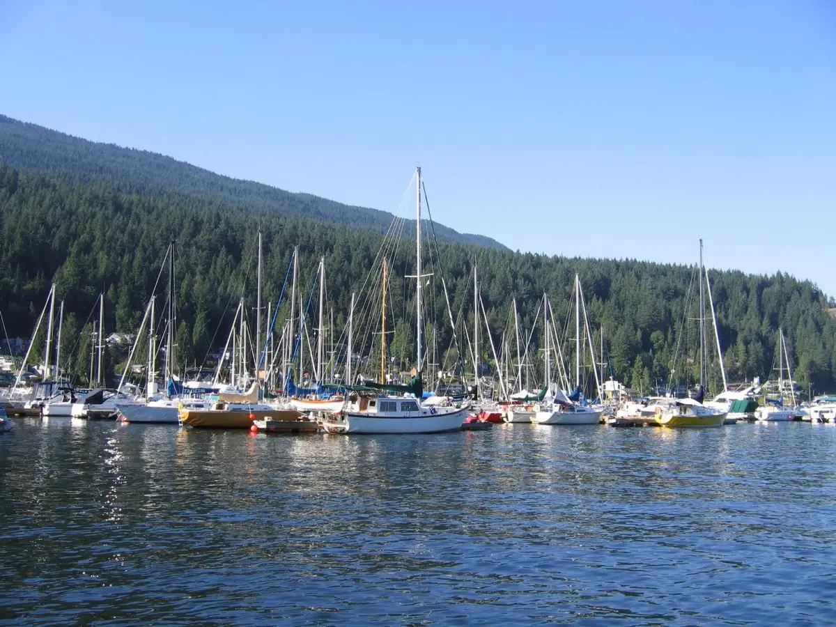
Choosing this neighbourhood means prioritizing outdoor lifestyle and quiet evenings over urban density and walk-to-work options. The community suits buyers who regularly utilize marine access for kayaking, paddleboarding, or boating, and who appreciate having immediate trailheads to the Baden Powell Trail system outside their door.
Conversely, buyers who require rapid transit connections to downtown Vancouver, who prefer large commercial shopping districts within walking distance, or who are sensitive to seasonal light variations may find adjacent neighbourhoods like Seymour, Blueridge, or Lynn Valley more aligned with their daily routine. Evaluating real estate is ultimately a balance of practical day-to-day trade-offs rather than purely aesthetic preferences.
If you are considering purchasing or selling property in the area and want clear, localized guidance on values and site-specific risks, please reach out directly through my contact page to start a conversation.
Frequently Asked Questions
How does winter sunlight in Deep Cove compare to other North Vancouver neighbourhoods?
Because Mount Seymour rises directly to the west, homes positioned low along the waterfront or along the base of the ridge lose direct line-of-sight sunlight earlier in the afternoon during winter months than properties in Edgemont or Upper Lonsdale. However, elevated sections of Cove Cliff receive broader southern exposures throughout the year.
What should I check when buying a waterfront home on Panorama Drive?
Waterfront buyers must examine the status of the water lot lease with the province or Port Authority, confirm the physical condition of docks and pilings against winter tides, verify geotechnical bank stability, and assess existing flood construction levels relative to district requirements.
Are secondary suites permitted in Deep Cove detached homes?
The District of North Vancouver permits secondary suites in most single-family detached zones, subject to specific building code requirements, ceiling heights, dedicated egress, and on-site parking spaces. Because many older Deep Cove lots have steep access or limited flat parking areas, verifying compliant parking stalls is often the primary logistical hurdle.
How severe is summer visitor traffic in the village?
From late May through September, warm weekends draw high visitor volumes to Panorama Park and Quarry Rock. The District implements local-resident-only parking restrictions on adjacent residential streets to manage traffic flow, but homeowners along Gallant Avenue and lower Panorama Drive must anticipate slower transit times through the village core during weekend afternoons.
Questions about the neighbourhoods?
Ask a specific question below or request a callback, it goes to Alex directly.
Alex Mackenzie
Royal LePage Sussex · North Vancouver REALTOR®
Alex Mackenzie is a licensed REALTOR® with Royal LePage Sussex, serving buyers and sellers across the North Shore. Royal LePage 2025 Royal LePage National Top 2% Award, Team Member; GVR Medallion Club, 2025 (team qualification).
The North Shore market in 60 seconds a month
Five current market numbers, three sentences on what they mean, and one action I'd consider in North Vancouver. Read a sample issue →
Unsubscribe anytime.